报告题目:Hyperspectral Remote Sensing and LiDAR Data Fusion
主讲人:杜谦 教授
主持人:谭琨 教授
报告时间:2019年4月29日14:30-16:00
报告地点:闵行校区河口海岸大楼A304会议室
主办单位:地理科学学院、地理信息科学教育部重点实验室
报告内容:
A hyperspectral imaging sensor collects hundreds of narrow spectral bands on solar reflectance, and its high spectral resolution offers powerful discriminant capability in separating objects or materials with subtle spectral discrepancy. LiDAR is an active remote sensing technology, using the pulsed laser to measure distances (ranges). LiDAR data products include LiDAR point cloud, Digital Surface Model (DSM), and Digital Elevation Model (DEM), etc. It has been of great interest to fuse remote sensing data from passive and active sensors. In particular, fusion of hyperspectral and LiDAR data has important applications in urban remote sensing. In this talk, feature-level fusion will be focused, where several popular spatial features, such as morphological profile (MP), extinction profile (EP), local binary pattern (LBP), and Gabor features, are studied. These features from both sensors are used for classification with kernel support vector machine (SVM) or kernel collaborative representation classifier (KCRC). The state-of-the-art method based on graph fusion and discriminant analysis is chosen for baseline comparison. Certainly, using the fused data can significantly improve classification accuracy. The experimental results on two sets of urban hyperspectral/LiDAR data show some other interesting results. Some practical considerations will also be discussed.

报告人简介:
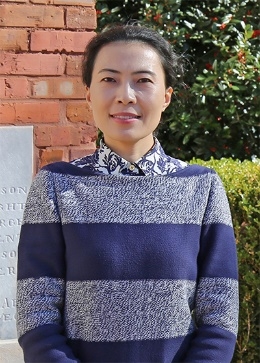
杜谦[Qian (Jenny) Du],博士,美国密西西比州立大学电子信息与计算机工程系Bobby Shackouls教授,国际电气与电子工程师协会会士(IEEE Fellow)、国际光学工程学会会士(SPIE Fellow),先后担任IEEE数据融合委员会(DFTC)联合主席(2009-2013)、国际模式识别协会(IAPR)委员会遥感模式识别(PRRS)主席(2010-2014)、IEEE地学与遥感委员会(GRSS)核心刊物J-STARS主编(2016-至今)等。曾受邀担任第4届IEEE GRSS WHISPERS、第7/8届IAPR Workshop PRRS、2019 IEEE Workshop MultiTemp等学术会议主席。
主要研究方向为高光谱图像处理与分析、模式识别、机器学习等,累计发表SCI论文200余篇,Google Scholar总引次数超过万次,h指数47。
主讲人:杜谦 教授
主持人:谭琨 教授
报告时间:2019年4月29日14:30-16:00
报告地点:闵行校区河口海岸大楼A304会议室
主办单位:地理科学学院、地理信息科学教育部重点实验室
报告内容:
A hyperspectral imaging sensor collects hundreds of narrow spectral bands on solar reflectance, and its high spectral resolution offers powerful discriminant capability in separating objects or materials with subtle spectral discrepancy. LiDAR is an active remote sensing technology, using the pulsed laser to measure distances (ranges). LiDAR data products include LiDAR point cloud, Digital Surface Model (DSM), and Digital Elevation Model (DEM), etc. It has been of great interest to fuse remote sensing data from passive and active sensors. In particular, fusion of hyperspectral and LiDAR data has important applications in urban remote sensing. In this talk, feature-level fusion will be focused, where several popular spatial features, such as morphological profile (MP), extinction profile (EP), local binary pattern (LBP), and Gabor features, are studied. These features from both sensors are used for classification with kernel support vector machine (SVM) or kernel collaborative representation classifier (KCRC). The state-of-the-art method based on graph fusion and discriminant analysis is chosen for baseline comparison. Certainly, using the fused data can significantly improve classification accuracy. The experimental results on two sets of urban hyperspectral/LiDAR data show some other interesting results. Some practical considerations will also be discussed.

报告人简介:
杜谦[Qian (Jenny) Du],博士,美国密西西比州立大学电子信息与计算机工程系Bobby Shackouls教授,国际电气与电子工程师协会会士(IEEE Fellow)、国际光学工程学会会士(SPIE Fellow),先后担任IEEE数据融合委员会(DFTC)联合主席(2009-2013)、国际模式识别协会(IAPR)委员会遥感模式识别(PRRS)主席(2010-2014)、IEEE地学与遥感委员会(GRSS)核心刊物J-STARS主编(2016-至今)等。曾受邀担任第4届IEEE GRSS WHISPERS、第7/8届IAPR Workshop PRRS、2019 IEEE Workshop MultiTemp等学术会议主席。
主要研究方向为高光谱图像处理与分析、模式识别、机器学习等,累计发表SCI论文200余篇,Google Scholar总引次数超过万次,h指数47。